17th April 2022
This was by far my favourite day of the trek (bar my time at Machu Picchu itself). It was less strenuous than the previous two days, but also we traversed a range of landscapes – mountains, valleys, tropical jungle, cloud forests, all with spectacular views.
The day started like the previous one – a 5.30am wake-up call with coca tea, half an hour to perform our ablutions, before breakfast. It had been a very cold night. I’d woken up a couple of times to put on more clothes- finally making use of the thermal top and socks I had brought with me, so the hot coca tea was very welcome. I chose not to use the toilet or bathroom (having heard horror stories about the mess, both literally and figuratively) and decided to find a panoramic bathroom (as Odi called it). I brushed my teeth, washed my face and then found what I thought was a secluded spot to pee. Turns out I did not choose wisely, and I ended up mooning one of the girls!
We set off at quarter to 7am, spending some minutes appreciating the location of our camp, Paq’aymayu (Pacaymayo), snugly nestled in a valley between two colossal mountain ranges. The guides assured me that the uphill climb of the day would last 2hrs. Still, it was a struggle. Not because it was a particularly challenging hike, but because I was having flashbacks to the previous day and the thought of more uphill climbing, more steps, and more exposure to the effects of the altitude was one that I did not relish.
It was a 45-minute uphill climb to our first stop, Runkuraqay. Runkuraqay is an archaeological site on a mountain of the same name, with circular and semicircular enclosures. It is believed to have served as a resting post for the travellers and runners. From this vantage point, one has a good view of ‘Dead woman’s pass’, and the profile of a woman looking at the sky.


An hour and a bit later, I arrived at the highest point of the day, Runkuraqay pass (3760m, 12335ft), from which point the hike was mostly downhill. It was here I found my stride. Skipping down the mountain, the tip of one trekking pole alternating with the foot on the opposite side. It was a dance. All that was missing was some music to serve as the soundtrack to the hike. I moved swiftly, and was the first to arrive at our next rest stop. There was a 100-step climb to the Sayaqmarka ruins. I took a look at those stairs and thought, ‘not today, satan’, opting instead to sit and enjoy the views, while waiting for the rest of the group.

The next stage of the trek was a straightforward hour and a half hike through a mountainous tropical jungle and cloud forest, on an undulating cobbled path. The clouds drew in, and the vistas were enshrouded in a thick fog. It was eerie and I felt like I was the only person in the world, in a movie that was one scream away from becoming a horror movie. I continued at quite a pace and arrived at the lunch campsite half an hour before we were expected.


Unfortunately the fog remained for the duration of lunch so we could not fully appreciate the views. Our last lunch of the trip was bittersweet – there was excitement that we had made it thus far, but also some sadness that we would soon be disbanded. I couldn’t have asked for a better group of people to have done the trek with. The celebratory cake whipped up by the chef, for dessert, went some way to lifting our mood.
A short downhill walk from the camp found us at Phuyupatamarca, ’City in the Clouds’ (3600m,11800ft). So named because these beautiful ruins are almost always covered by mist, therefore you feel like you are literally in the clouds. There are a number of constructions on the site, including ritual baths, squares, water channels and viewing platforms. On a clear day, one can see clear across the valley and other ruins on the trek, Intipata and Wiñaywayna.


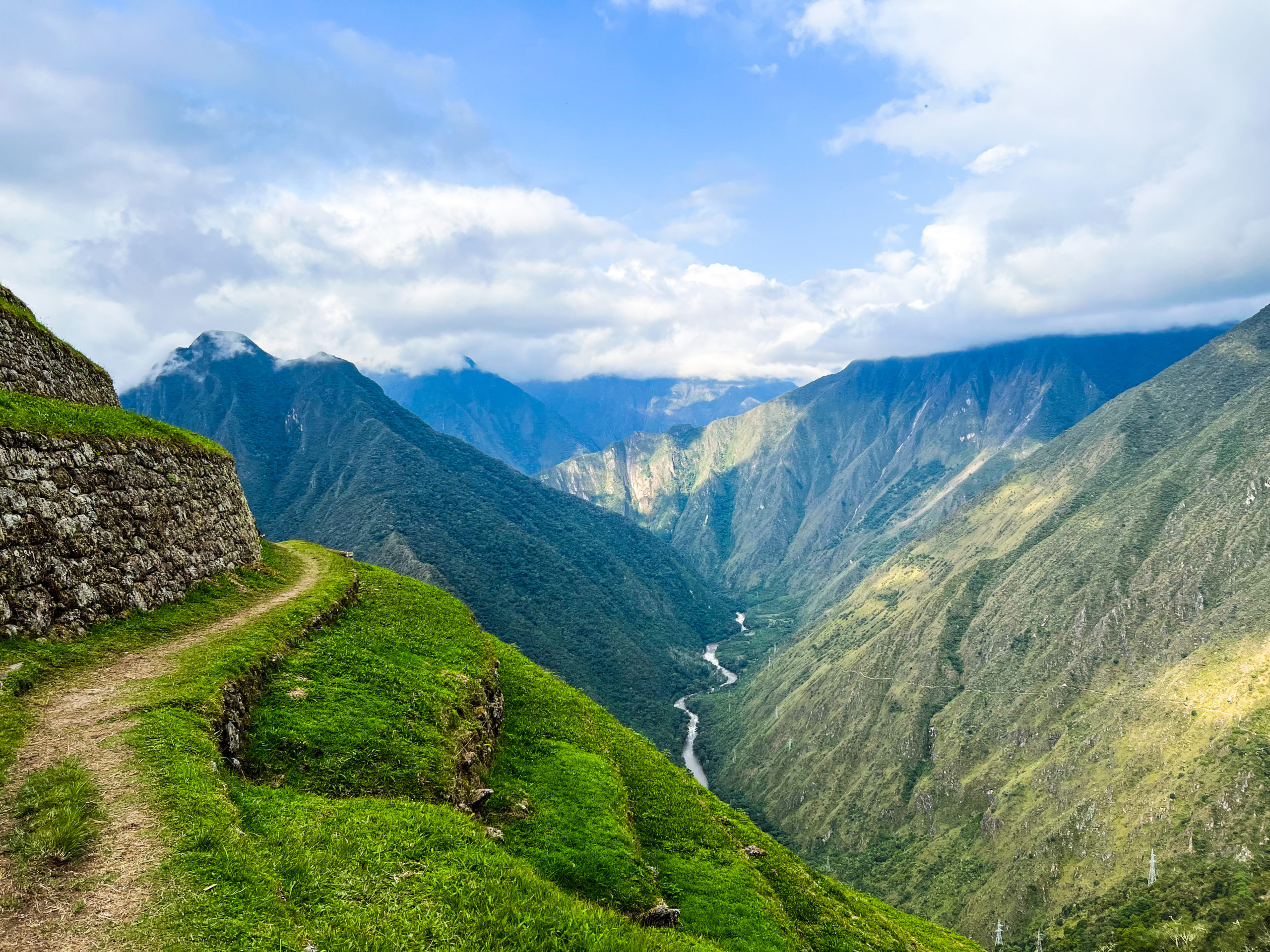
A further 90-minute hike, through the jungle and down mountain passes, punctuated by expansive views across the valley found us at our last rest stop of the day, the ruins of Intipata (‘Place of the Sun or Sun Terrace’). Located at 2800m (9180ft), it is an impressive construction made up of striking vertiginous agricultural terraces, which were used by the Incas, to grow different crops. The terraces were thus designed to prevent the natural erosion of the mountain face. On the lower levels of the terraces are buildings thought to have served as sites for religious ceremonies.


Even more spectacular though was the view from the terraces – panoramic, out-of-this-world views over the entire Urubamba Valley and Rio Urubamba (It was the same river we had crossed on the first day of the trek. It is known by different names along its course, and is called Rio Vilcanota at this point upstream). This was hands down the most sensational, breathtaking, unforgettable view of the trek.


The group took a few minutes to celebrate our arrival, it marked almost the end of Day 3, and most people continued on to camp. Franzi and I stayed behind, taking more pictures (of course) but also enjoying those enthralling views.


Afterwards, it was a short 20-minute walk to camp at Wiñaywayna (2650m, 8690ft). We observed the same routine as the previous days – snacks, dinner and then bedtime. We were encouraged to have an early night as we would be woken up at 3.30am to begin the final day’s trek to Machu Picchu.
No one:
No one:
Chino: Did you know I was the fastest trekker in my group on Day 3? (…made up for the embarrassment of Day 2!)
Every one:

Total Trek Time: 6 hours (9hrs is typically quoted)
Distance covered: 9.9miles (16km)
Elevation gain: 400m